The Gildencroft
The Gildencroft has a long and fascinating history. It was once much larger, covering virtually the whole of
St Augustines parish to the west and south of the churchyard, as well as parts of the adjoining detached portion of St Clements parish down to the river to the west, St Martin's at Oak parish to the south and the area now known as New Catton to the north of the old City Wall. Over the centuries portions of land were sold off and built over and today it is probably less than a tenth of its original size (right).
Etymology
It isnt known with certainty what Gildencroft means. Before the mid-13th century the area was referred to in legal documents as the 'croft of St Augustine' but from about 1250 onwards it was more commonly described as the 'Gildenecroft' or 'Gyldenecroft', which may indicate a change of ownership or use at around this time. Gildencroft may simply indicate that this was land once owned or leased to a craft guild or religious or charitable guild, though no documentary evidence has been found to support this theory. Some historians have argued that Gildencroft actually means the manorial court where geld or tax was collected; the land hereabouts having once been part of Tolthorpe or 'Tokethorp' Manor.
To add to the confusion, some 17th- and 18th-century plans of Norwich name the area the Gilding' or 'Gipping' Croft (see map right), a placename that may allude to a local legend mentioned by the 16th-century, Lowestoft-born satirist Thomas Nashe in his Lenten Stuffe (see title page right below) that the smoky gilding of herrings was once carried on in the Guilding Cross in the parish of St Saviours (now stumped up by the roots) Could this refer to Stumps Cross? (See the section on local place names on this website.) Gipping means gutting fish, while gilding means curing them in a smokehouse, to make, for example, the proverbial 'red herrings'. Unlikely as this folk etymology sounds, it is worth noting that there were once several smokehouses in the nearby Fishergate area of Ultra Aquam or Norwich 'Over the Water (the old name for the leet [administrative district] of Norwich north of the River Wensum), where fish carried inland by river from Lowestoft and Great Yarmouth's North Sea fisheries was once unloaded.
The Lathes
For centuries the Gildencroft was in agricultural use as the grange farm (meaning it was farmed by stewards rather than tenant farmers) of Tolthorp Manor (once owned by Sir John Fastolf, the gentleman from whom Shakespeare is thought to have taken the name for his larger-than-life rogue Sir Jack Falstaff). The farm was known as the Lathes (a dialect word for a type of barn or grain larder). Comprising 50 acres of arable and nine of pasture the farm straddled the parishs northern boundary. With the completion of the city walls in the mid-14th century the southern portion of the farm became cut off from the manorial land to the north, but the land inside the wall remained essentially rural and open until well into the 19th century.
The Lathes was held in the 15th century by the Great Hospital of St Giles in Bishopsgate, which employed a Serjeant at Ploughs and Carts (or farm steward) to manage it. The farm accounts of two of the stewards, John Dernell and John Boys, dating from 1417 and 1428/9 respectively, have survived and make fascinating reading. The arable portion of the farm was divided into five parcels of ten acres each, which were sown in strict rotation. One parcel with winter corn, three with spring corn and one left fallow for next seasons winter corn.
The steward was paid 14 old pence a week and was expected to work the farm from Monday to Saturday except when the weather was too wet. In addition to Sundays he was allowed 39 days' paid leave a year to observe religious holidays and festivals, all of which are meticulously recorded in the farm's account book. A clerk, who could read and write in Latin and English, and keep simple accounts, was employed by the steward at a wage of 1d a week to write up the farm accounts. The steward was also allowed to employ an assistant during busy periods, such as harvest time. He was also allowed to hire out the farm's horses and wagons for moving heavy materials such as stones, scrap iron, tiles and marl (a type of soil made of clay and lime used as a soil fertiliser). It might take well over a week to transport a load of iron by wagon to Great Yarmouth. Surplus farm produce not needed by the Great Hospital could be sold on Norwich market.
Later, ownership (or at least management) of The Lathes passed to Norwich's City Corporation. The name was still being used in late 18th-century legal documents and there was still an orchard and nursery roughly on the site of Quintain Mews off Sussex Street in the 19th century. Indeed a few farm buildings remained just west of the churchyard until the 20th century. An ancient timber-framed building, now lost, still stood here in 1904 and there were still a few tumbled-down outbuildings as late as 1946. Even today a few crab apple trees survive around the edges of the car park at the end of Chatham Street, an area marked on a map of The Lathes from about 1770 as Toft Garden and Orchard. In the 1970s the name of the medieval farm was revived for a new estate of houses managed by Broadland Housing Association.
The Jousting Acre
Another part of the Gildencroft, located between present-day Bakers Road and St Martins at Oak Wall Lane, was known as the Jousting Acre. Here Norwichs knights and men-at-arms once practiced martial skills such as tilting at quintains with lances on horseback and archery. Edward III, Queen Phillippa and their young son, Edward the Black Prince, are known to have attended a jousting tournament in Norwich on St Valentines Day, 1340. It isn't known for sure where the event was staged, but the Jousting Acre is a distinct possibility (right). A small hill, known as Tut or Tot Hill (possibly meaning look-out hill) once stood to the west of the Jousting Acre somewhere near the junction of Bakers Road and St Martin's Road. Archery 'butts' were also set up in this area for the compulsory archery and cross bow practice that young men had to perform in the
Middle Ages.
By the 17th century jousting in the Gildencroft had long been succeeded by less aristocratic sports. One part, known as the Folly Grounds, had a tavern called the Tabors Folly. Citizens congregated here in the open air on summer's evenings to escape the crowded and smelly tenements of the city to sport, dance and make merry. Their merry making seems to have worried the City authorities. In 1671 the Bellman (Norwich's name for its town crier) was ordered to give notice to the Inhabitants beyond the Water that they forbear to spoil the Grass in the Gilding Croft by immoderate Campings and Dauncing there. Camping or camp-ball was an early form of football played by two large teams (right). Matches were long and rough and often got out of hand with competitors frequently suffering bruises and broken bones and occasionally even death. The area seems to have been notorious for the wildness of its inhabitants at this time. In 1682 the City Marshals were ordered to apprehend boys and young fellows playing in the Guyldencroft and St Augustines churchyard on the Lords Day in service and sermon time.
In 1724 Daniel Defoe noted that much of the ground in Norwich lay open in pasture-fields and gardens
and the [city] walls seem to be placed, as if they expected that the city would in time increase sufficiently to fill up with buildings. The Gildencroft was just such an area. At this period it was bounded on the north by the remains of the city wall, including St Augustine's Gate, which stood at the top of St Augustine's Street until 1794; on its the west by St Martin's at Oak Street and St Martin's Gate (and beyond that the River Wensum); on its the east by St Augustines Street and Pitt (or just plain 'pit street' - it once housed a rubbish pit); and on its south by
St Martins Lane, also known as Whores Lane. The main approach to the Gildencroft from the Guildhall in the city's central Mancroft area was via the Gildengate, a route along St Georges Street (also known as Middle Street) towards Botolph Street.
The Gildencroft reputation for wildness persisted well into the 19th century. As late as the 1890s tales were still current of 'the Gildencroft bogey', a menacing phantom with 'tay-sarcer [tea saucer]' sized eyes, which was 'want to rush out and chase lonely wayfarers' very much like Black Shuck, the infamous phantom hound of East Anglia's folklore.
Gradually, the Gildencroft began to be parcelled up and sold off. In the 16th century a row of seven cottages was built along the south side of the churchyard. These have survived (or at least most of them have) and are reputed to be the longest surviving continuous row of Tudor cottages in England (right).
In 1670 the Norwich Society of Friends (Quakers) bought an acre of land in the south-west quarter of the Gildencroft for use as a burial ground (right). The land had formerly been known as the Dutch pasture or buttercup meadow. In 1694, the Quakers purchased an adjoining paddock on which they build a Meeting House. This opened in 1699 and for many years the Quakers who met here were regularly persecuted by those who objected to their Non-conformist religious obsevances.
In 1813 Norwich's small Jewish congregation leased a plot of land in the Gildencroft for use as a cemetery. (Click here for more information)
In the 1820s a strip of land connecting St Augustines Street and Oak Street was developed for housing. This was later named Sussex Street, possibly after a public house called the Sussex Arms, now a takeaway, which still stands at the junction with St Augustines Street. A rare stone streetname can be seen embedded high up on its wall facing Sussex Street, while across the street one of the terraced cottages has a stone plaque with the date 1824 and the initials 'BHJ'; but what they stand for no one knows.
In 1892 land now covered by the Gildencroft Recreation Ground was purchased (or re-purchased) by Norwich City Corporation for £2,700 and made into a public park, which was opened by the mayor. It was one of the first public open spaces in Norwich. As well as well-kept paths and benches were the public could stroll and sit there was a popular bowling green, which survived until the 1980s. In 2006 Norwich City Council began a programme of improvements to the park.
A specially designed, sculpted brick and stone pillar, created by artist Gary Breeze, depicting the Gildencroft's association with jousting and other activities was placed at a new entrance to Gildencroft Park in
Pitt Street (right).
Text © S. J. McLaren, 2013 |
|
|
|
Click on the images below to view a larger image and more information
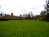
Gildencroft Recreation Ground, a remnant of the medieval Gildencroft
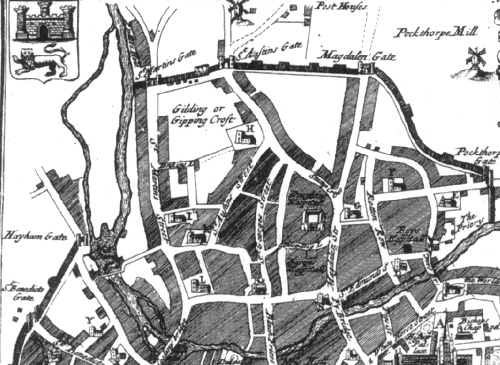
The 'Gilding' or 'Gipping Croft' in a plan of Norwich dated 1710
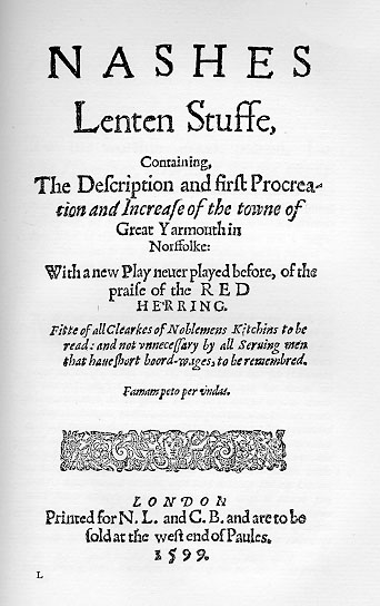
Title page of Thomas Nashe's
Lenten Stuffe, first published in 1599
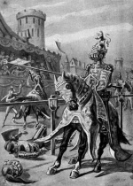
Fanciful depiction King Edward III jousting in the Gildencroft from a Victorian children's book published by Jarrolds entitled
The Glory and Sorrow of Norwich
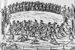
A boisterous game of 'camping' in full swing
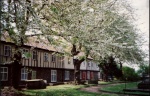
Gildencroft's Tudor cottages
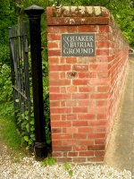
Entrance to the Gildencroft Quaker Burial Ground
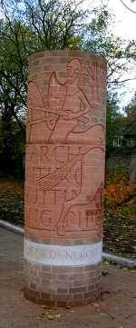
The Gildencroft Pillar
|


.jpg)